An iconic mountain summit, a peaceful waterfall, panoramic vistas. Whatever you're seeking, the Smokies offer a wide range of hiking opportunities, from easy walks to challenging climbs. Here are five great hikes in Great Smoky Mountains National Park.
With stunning views, diverse landscapes, and opportunities for both relaxation and adventure, Great Smoky Mountains is one of the most beloved national parks in the U.S. Before you head out, though, here are some tips:
- Because some of these trails are so popular and can become crowded with limited parking, we list some alternative hikes as well.
- The park does not charge an entrance fee, but all vehicles parking for longer than 15 minutes anywhere in the park are required to have a parking tag. Many of the trailheads have very limited parking so consider taking a shuttle and avoiding the stress.
- Bring (or download) a map as GPS may not be accurate in the mountains.
- Don’t bring your dog, as they are not welcome on any of the trails.
- Always check the NPS website for the latest conditions and closures.
And now, here are five great hikes in Great Smoky Mountains NP:
1. Alum Cave Trail
One of the park’s most popular hikes, the Alum Cave Trail offers a perfect mix of natural beauty and geological wonder. The trail climbs through lush forests and past rocky outcroppings before reaching the dramatic Alum Cave Bluffs. These towering white sandstone bluffs offer stunning views of the surrounding mountains. The trail also passes through Arch Rock, a natural rock arch, and provides glimpses of the park’s diverse ecosystems. It’s a rewarding hike that’s moderately challenging and perfect for those looking for a mix of adventure and scenic views.
Distance: 4.6 miles (round-trip)
Difficulty: Moderate
Elevation Gain: 1,125 feet
Alternative hike: Andrews Bald
2. Grotto Falls Trail
For a shorter, family-friendly trail that leads to a beautiful waterfall, the Grotto Falls Trail is a fantastic choice. This easy-to-moderate trail meanders through a peaceful forest and brings you to Grotto Falls, a 25-foot waterfall that you can actually walk behind! It’s one of the few waterfalls in the Smokies where you can get up close and personal with the flowing water. The trail is particularly picturesque in spring when wildflowers bloom along the path, and the waterfall is especially captivating after rain.
Distance: 2.6 miles (Round-trip)
Difficulty: Moderate
Elevation Gain: 600 feet
Alternative hike: Baskins Creek Falls
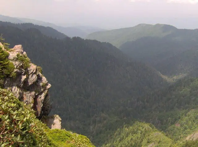
The Charlies Bunion Trail is one of the best hikes for panoramic mountain views. This trail follows a section of the Appalachian Trail and climbs through the lush forests of the Smokies before reaching Charlies Bunion, a rocky outcrop offering 360-degree views of the surrounding mountains and valleys. The trail is moderately strenuous, with a steady climb and some rocky terrain, but the views at the end are well worth the effort. On clear days, you can see deep into Tennessee and North Carolina, making this a favorite for photographers and hikers alike.
Difficulty: Moderate
Distance: 8 miles (Round-trip)
Elevation Gain: 1,700 feet
Alternate hike: Chimney Tops Overlook

For a more challenging hike, the Mount LeConte Trail is a must for experienced hikers. At 10 miles (16.1 km) roundtrip, this is the shortest of the five routes to Mount LeConte, one of the highest peaks in the Smokies. It’s a strenuous adventure, but the views from the summit make it one of the park’s most rewarding hikes. The trail ascends through dense forests, past wildflower-filled meadows, and over rocky outcrops. At the top, hikers are rewarded with panoramic views and the chance to visit LeConte Lodge, the highest lodge in the park, where you can rest and take in the mountain scenery. This trail is tough but offers a truly unforgettable experience.
Difficulty: Difficult
Distance: 10 miles (Round-trip)
Elevation Gain: 2,700 feet
Alternative hikes: Appalachian Trail & Boulevard Trail to Mount LeConte (16.2 miles roundtrip); Bullhead Trail to Mount LeConte (13.6 miles roundtrip); Trillium Gap Trail to Mount LeConte (13 miles roundtrip); Rainbow Falls Trail to Mount LeConte (13 miles roundtrip)

Kuwohi—formerly known as Clingmans Dome, and recently restored to its native American name—is deeply significant in Cherokee culture and a place of spiritual importance. In Cherokee syllabary, the name is ᎫᏬᎯ and means “mulberry place”. As the highest point in the park, Kuwohi offers breathtaking views. The paved trail is 0.5 miles each way—steep but rewarding—and leads to an observation tower with stunning 360-degree vistas. In winter, road closures add a 7-mile hike, but snowy landscapes and crystal-clear skies make the journey worthwhile. Whether you’re visiting for the views or its rich history, this iconic destination leaves a lasting impression year-round.
Distance: 0.5 miles in summer; 7 miles in winter
Difficulty: strenuous
Elevation gain: 330 feet in summer; 1,200 feet in winter
Alternative: There is nothing like it!
Top photo by Freedom Naruk/Freepik

